Search

Introduction

Dear Visitors,                                                                                                                                    April 21, 2017

Thank you for stopping at FlatEarthLunacy.com

As a scientist with college degree in Astronomy, minor in Physics and Mathematics, I was appalled to find folks telling outright falsities and presenting bad science to bolster suspicion of our known accepted reality - that the Earth is a beautiful blue globe.

This blog clearly shows scientific proofs that debunk everything that flat Earth proponents claim.  Here we also expose the comments those YouTube video channels delete, because they don't want you to see them.

The Earth is not flat.  That claim is a conspiracy theory perpetrated by ignorant people who have ulterior personal motives and agendas.

The Earth is a beautiful blue spheroid globe spinning on an axis 23.5° once each day, and orbiting the Sun every 365.25 days.

   JonahTheScientist.png


kind regards,  Jonah The Scientist


(This email address is being protected from spambots. You need JavaScript enabled to view it.)                 © FlatEarthLunacy.com (2015 - 2022) - All rights reserved

Get notified of new articles on Twitter / Facebooktwitter.com/FlatEarthLunacy , facebook.com/flatearthlunacyofficial   

JonahTheScientist SALES / Recommendations: STEM (Science, Technology, Engineering and Math) science projects for young adults, and science books for everyone.  Enjoy! 


Here is a list of our copyright and USPTO Legal Trademarks:


Trademark of name “Jonah The Scientist”
Trademark of name “Flat Earth Lunacy” 
Trademark of logo of “Jonah The Scientist”
Copyright of artwork at the US Library of Congress, for “JonahTheScientist Official Logo”
In any word combination, script, color, or word separation by blanks or other characters.

Our internet blog/web sites are exclusively licensed to FlatEarthLunacy.com, twitter.com/FlatEarthLunacy, facebook.com/flatearthlunacyofficial AND https://www.youtube.com/channel/UC7ipUKERU0tzYFxALJBli4A/discussion.

Our articles and screen shots authorized under - Copyright Disclaimer Under Section 107 of the Copyright Act 1976.  Allowance is made for "fair use" for purposes such as criticism, comment, news reporting, teaching, scholarship, and research.
Section 107 of the U.S. Copyright Act states: “Notwithstanding the provisions of sections 106 and 106A, the fair use of a copyrighted work, including such use by reproduction in copies or phonorecords or by any other means specified by that section, for purposes such as criticism, comment, news reporting, teaching (including multiple copies for classroom use), scholarship, or research, is not an infringement of copyright.” This internet site may contain certain copyrighted works that were not specifically authorized to be used by the copyright holder(s), but which we believe in good faith are protected by federal law and the fair use doctrine for one or more of the reasons noted above. 

- - - - - - - - - - - - - - - - - - - - - - - - - - - - - - - - - - - - - - - - - - - - - - - - - - - - - - - - - - - - - - - - - - - - - - - - - - - - - - - - - - 


FECORE - their "Force the Level" experiment FAIL

  
Dear Readers,

When this FECORE experiment was analyzed by real surveyors many errors were found, and questions left unanswered.  

From FECORE:
Force The Level Project August 2019 Update
https://fecore.org/force-the-level-project-august-2019-update/


   2019-09-13_14-29-08.png

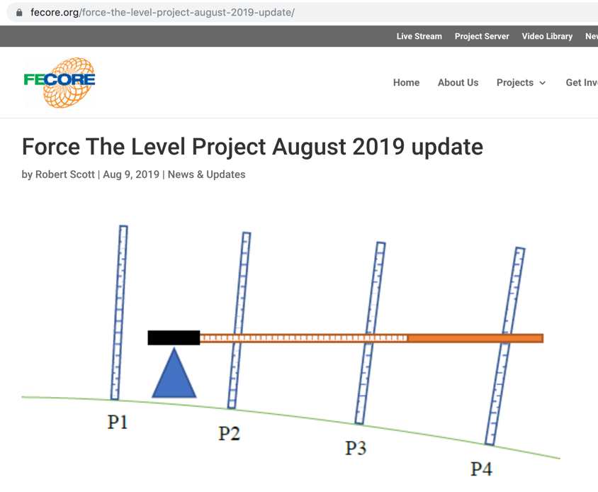
On May 18th and 19th FECORE volunteers met at 96th Ave and Tower Rd. in Commerce, Colorado. They made a first of its kind 4 rod high precision differential leveling measurement. The method was designed to take advantage of the high precision of the Trimble DiNi auto level which is capable of detecting height changes within 1.3 mm per kilometer that is about than 1/10,000th of a foot in 120 meters.

This project is an attempt to verify the constantly changing direction of gravity called the geopotential as required by the WGS84 model by direct measurement of a land surface using the surveying technique known as differential leveling.

The actual method was refined over 8 months of research. The May 2019 measurements were a validation of this method.
The result is a treasure of data which indicates that this method is capable of detecting minute changes in the geopotential from one location to another over relatively short distances. That means the WGS84 constructed data for a specific portion of the earth’s surface can be compared with actual measurements of that location.

As depicted in the diagram above the WGS84 construct theorizes a gradual and consistent change in the geopotential as distance increases.

At the time of this newsletter the results are being compiled and a full presentation is being created.

A full explanation of the method used will be made available to any schools teaching surveying techniques so the test can be replicated.

- - - - - 

Debunk by The Maine Surveyor
Questions for FECORE - Force the Level - Part 1
https://www.youtube.com/watch?v=p1n1AxJJMWk

Debunk by The Maine Surveyor
FECORE - Farce the Level
https://www.youtube.com/watch?v=AxRJEPS4SY4


- - - - -


Published on – September 12, 2019

Discussion at - https://www.youtube.com/channel/UC7ipUKERU0tzYFxALJBli4A/discussion

Our home page all articles - http://flatearthlunacy.com

kind regards, JonahTheScientist